Tiled Sketchup Model
File Name: Bos3D_[Tile]_SkletchUp.skp
Updated: July 2020
Format: SketchUp 2015 (.skp)
Description
The Boston Planning and Development Agency (BPDA) maintains a 3D model of the city as a visualization and analytical tool for understanding ideas related to the future of neighborhoods. The BPDA shares the Boston 3D city model in several formats intended to facilitate collaboration between diverse communities who have an interest in understanding places in the city as they have changed or as they may be changed. Find an overview of the BPDA's city model sharing strategy in Boston 3D User Guide.
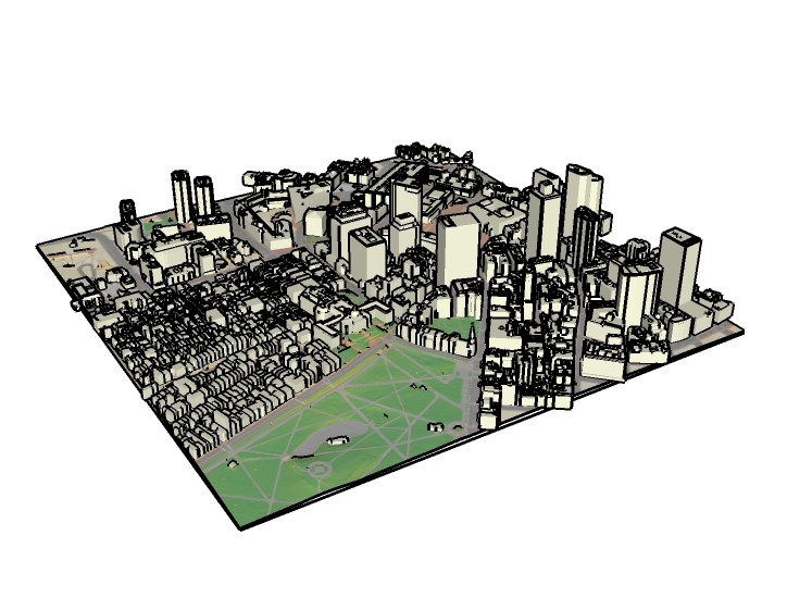
Each of the Tiled 3D Models combines a terrain mesh with a draped basemap, a collection of 3D building models, and a registration frame. These layers have been transformed from the city's GIS data into a SketchUp model that is easy to explore and to edit.
Purpose
These models are intended to provide designers and others with a ready-made context model for developing design ideas and as a means of getting 3D models from designers and others back into the city's 3D GIS. These models provide a common operating picture for developers and members of the public to understand development projects. Students and historians can use these models as a means of recording and sharing knowledge about the history of the city in 3D.
Sources
These SketchUp models combine the four components of the BPDA's city model into one integrated city model for each tile. For information about sources, visit the metadata opage for each of the components:
Organization
Each of the SketchUp tiles uses the same layering (or tags in Sketychup 2020 or newer) scheme to control visibility of the different model components. The components are grouped with names that reflect the component name and tile name. Building models are further grouped individually and named according to the unique model identifier that can be looked up in the city-wide Model Attribute Table described in the documentation for Boston 3D Buildings.
Coordinate System
Projected Coordinate System:State Plane Massachusetts Mainland FIPS 2001 Feet, NAD1983
Coordinates are offset by 732,200 feet West and 2,902,900 feet South.
Vertical Coordinate System: NAVD 88 Feet (Height)
See the Bos3D User Guide for more discussion of the BOS_Shift Coordinate System.
SketchUp Geolocation Tips
These models use the BOS_Shift Coordinate System described above. This spatial referencing system facilitites model-sharing with other modeling tools and GIS while preserving precise registration. When importing geometry from other tools into sketchup,complete each import by clicking SketchUp model origin (intersection of axes) to specify the insertionpoint for imported data.
To use SketchUp's geolocation tool and KMZ export, drag your tile center (from the Frame layer) to the model origin. Consult the Bos3d_Grid.csv tolearn the Latitude and Longitude of the tile center, and enter this in the Sketchup > Model Info > Geo-Location dialog (a href="../images/skp_geolocation.png">See screen-shot) Modifying your model in this way will cause geometry imported from Bos3D-oriented data-sets to land very far from the model origin.
Usage Notes
- The terrain looks better if you use the Window > Soften / Smooth Edges to soften coplainer edges within 50 Degrees. (see screenshot)
- To skin the terrain with the 2013 or 1946 Aerial photo or a custom basemap image use the Materials > Eye Dropper to select the terrain material, then choose the desired ground plan image in the Edit tab. (See Screenshot)
- These SketchUp models will open with their display units set to feet.
- Updates will be published as entirely new tiled models, or as city-wide update models that wrap up just the new and retired buildings for the period since the last update. For more information regarding updates, see Bos3d Buildings