Tiled Terrain Models
GIS File Name: Bos3D_[tile]_Terrain_2011
Updated:
- Represents terrain observed April 2011
- Updated, June 2020 to add 2005 MassGIS terrain outside of Boston.
Format: Wavefront Object (.obj)
Description
The Boston Planning and Development Agency (BPDA) maintains a 3D model of the city as a visualization and analytical tool for understanding ideas related to the future of neighborhoods. The BPDA shares the Boston 3D city model in several formats intended to facilitate collaboration between diverse communities who have an interest in understanding places in the city as they have changed or as they may be changed. Find an overview of the BPDA's city model sharing strategy in Boston 3D User Guide.
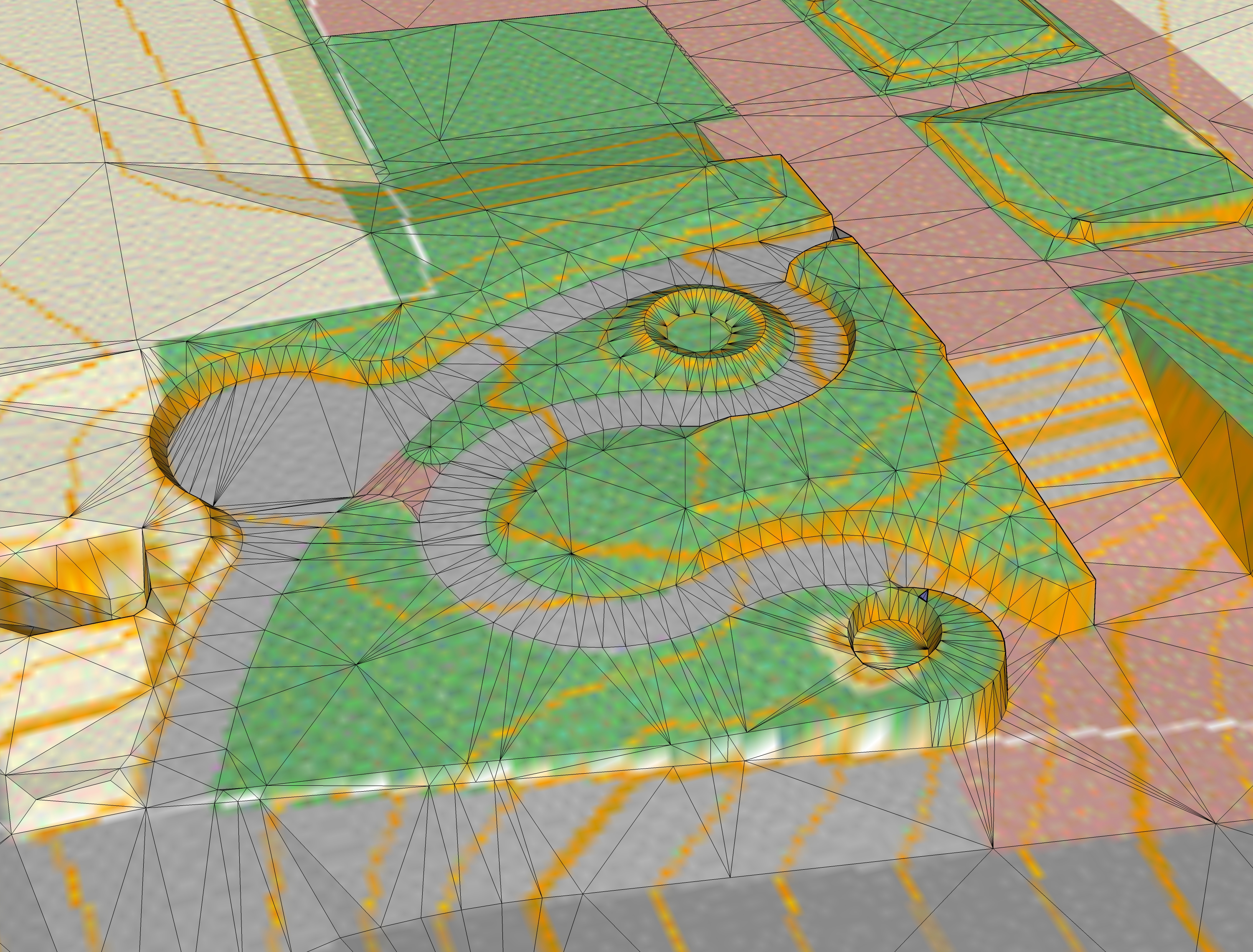
The terrain layer was developed by stereo photogrammetry, capturing critical elevation points and grade-breaklines with a precision of about one foot. Delaunay triangulation was used to create a surface mesh using the ESRI ARCGIS TIN Tiangulation tool, and converted to .obj format. The result is a crisp and efficient, highly detailed terrain mesh.
The BOS3D Planimetric Basemap is draped as a texture on each terrain tile.
Purpose
These tiled terrain models are intended to provide a precise reference for locating 3d models that can be shared among collaborators using a variety of tools. They can be used as a setting and a initial condition for detailed design studies. These models also provide an accuate bare-earth reference for shadow and inter-visibility analysis.
Sources
These tiled terrain layers were made with terrain breaklines and masspoints derived form the 2011 Infotech survey. Outside the Boston city limit, the MassGIS 1:5000 Breaklines and Masspoints (2005) were used to create a slightly less detailed context model.
Organization
Each tiled terrain download is a folder that contains an .OBJ file, a material (.mtl) file and a materials folder that contains the groundplan texture. The folder and the .obj file are named with the prefix BOS3D_, the tile name, e.g. G_5_ then Terrain_2011.
Coordinate System
See the Bos3D User Guide for more discussion of the BOS_Shift Coordinate System.
Projected Coordinate System: State Plane Massachusetts Mainland FIPS 2001 Feet, NAD1983
Coordinate offsets: 732,200 feet West and 2,902,900 feet South.
Vertical Coordinate System: NAVD 88 Feet (Height)
Usage Notes
- When importing Wavefront Object files from the BPDA into your modeling tool, specify that the Z Axis: Up and the Y Axis: Forward. Otherwise your terrain model will beoriented incorrectly.
- The tile frame included with each terrain model can be used to register models with neighboring tiles or with the city-wide tile grid. The elevation of the tile polygon is always 0.
- For applications that call for editing the terrain model, we recommend that you start with the DTM breaklines and DTM masspoints included with the DXF models. Adjust them to represent your new grades. Then use the delaunay triangulation tools inyour modeler to create a new mesh.
- It is easy to substitute an alternate groundplan image as the texture, including our The Boston 3D 2020 Orthophoto, or a custom ground-plan created using the the Boston 3D PDF Basemap