Tiled PDF Base Map
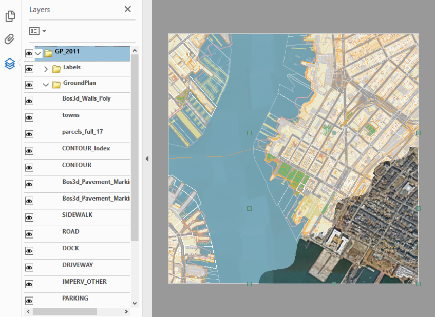
Control visibilitiy of vector layers.
File Name: BOS3D_PDF_Basemap.pdf
Format: Adobe PDF
Updated: 2011
Description
The Boston Planning and Development Agency (BPDA) maintains a 3D model of the city as a visualization and analytical tool for understanding ideas related to the future of neighborhoods. The BPDA shares the Boston 3D city model in several formats intended to facilitate collaboration between diverse communities who have an interest in understanding places in the city as they have changed or as they may be changed. Find an overview of the BPDA's city model sharing strategy in Boston 3D User Guide.
Each of the PDF documents includes sylized vector linework representing the following features:
- Planimetric Groundplan (edge of pavement, shorelines, etc.)
- Street Name labels
- One foot Contours (Elevated)
- Building Model Footprints
- Property Parcels
- Spring 2020 Areial Photo (1-foot resolution)
Purpose
The Tiled PDF Basemap is a vector-based basemap that has layers that can be selectively turned on and off using Adobe Acrobat to create custom basemaps. These files can also be edited in Adobe Illustrator or Photoshop to apply custom styling or to edit features to reflect site changes. Once edited, the tiled basemap can be exported to a high-resolution groundplan image that canbe draped ontothe terrain mesh in a 3d Model.
Sources
These layers come from a variety of sources. Most of them are from the 2011 photogrametric survey by InfoTech. Buildng Model footprints are made from the Boston 3D Current 3D buildng Models. Property parcels (2017) are downloaded from Boston Open Data.
Coordinate System
Although these PDF files are not georeferenced, they are based on the same Massachusetts State Plan projection to match exactly with the other components of the BPDA's Boston 3D city model.
Usage Notes
- To control the individual layers in this PDF, open in AcrobatReader or Acrobat Pro, and open the Layers panel.
- To create a custom basemap for a tile open the PDF in an editing tool, and save as a high-resolution image. Make sure that the extents of the image are the exact same extents of to original PDF. Then you can apply this new basemap as a texture in Sketchup (See Screenshot).
- The linework in this PDF has thousands of vertices -- as opposed to nice smooth bizier curves. Therefore, we don't recommend trying to edit the existing lines. You wil have better luck using the PDF layers -- especially the 2020 photo -- as a guide, and using your editing tool tocreate new geometry to "patch over" tha areas that you want to change.