Boston 3D Tile Grid
File Name: BOS3D_Tile_Grid
Updated: July 6, 2020
Formats: Autodesk DXF, ESRI Shapefile, Plain Text
Description
The Boston Planning and Development Agency (BPDA) maintains a 3D model of the city as a visualization and analytical tool for understanding ideas related to the future of neighborhoods. The BPDA shares the Boston 3D city model in several formats intended to facilitate collaboration between diverse communities who have an interest in understanding places in the city as they have changed or as they may be changed. Find an overview of the BPDA's city model sharing strategy in Boston 3D User Guide.
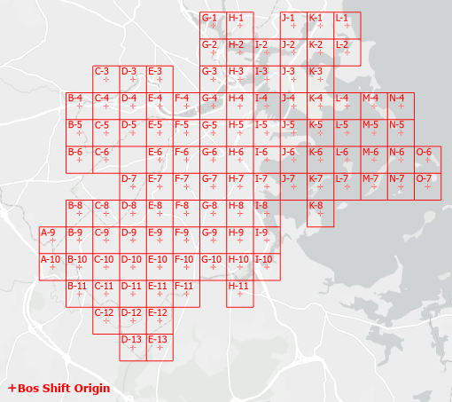
The city-wide tile grid includes the tile-grid outlines and centroids. The origin pont of the BOS_Shift coordinate system is also included as a point.
Purpose
Import the city-wide tile-grid in the BOS_Shift_Feet coordinate system into your 3d modeling tool as a reference for the registration of tiled data-sets.
The Unshifted_Feet version can be improted into documents from surveyors to provide a drag-and-snap reference for registering massachusetts state plane documents with the BOS_Shift coordinate system.
The Tile Grid in ESRI Shape-file version is useful for GIS users who want to cut out city-model modules with their own data layers.
The Tile Grid attribute table that is integrated with the shapefile format version, available as a plain text (comma separated values) table, includes coordinate system information for the center of each tile; invaluable for transforming tiled data to other coordinate referencing systems.
Coordinate System
See the Bos3D User Guide for more discussion of the BOS_Shift Coordinate System.
Projected Coordinate System: State Plane Massachusetts Mainland FIPS 2001 Feet, NAD1983
Coordinate offsets: 732,200 feet West and 2,902,900 feet South.
Vertical Coordinate System: NAVD 88 Feet (Height)
Usage Notes
- When importing DXF data in the BOS_Shift or the Massachusetts State Plane (Mainland) projection, be sure to declare the units as Feet.
Download Tile Grid Resources
- Bos3D_Tile_Grid_Shift_Ft.dxf
Bos3d Tile scheme in DXF(r14) format (Bos_Shift Coordinate System) - Bos3D_Tile_Grid_Poly.shp
Bos3d Tile Polygons in ESRI Shapefile format. - Bos3D_Tile_Grid_Pts.shp
Bos3d Tile Centers and Origin in ESRI Shapefile format. - Bos3D_Tile_Grid.csv
Bos3d Tile Attributes in CSV format. - Bos3D_Tile_Grid_NoShift_Ft.dxf
Bos3d Tile scheme in DXF(r14) format (Massachusetts State Plane Coordinate System)
This tile layer can be useful as a reference for shifting CAD data in State Plane Coordinates to the origin of the BOS_Shift coordinate system
Data Dictionary for Tile Grid Attribute Table (Shapefile or CSV)
This attribute table is a reference for tile identifiers and tile-center coordinates.
| Field Name | Type | Description |
|---|---|---|
Town_Code |
Text |
A three letter abbreviation of the town name. |
Tile_Label |
Text |
a hyphenated label consisting of the letter designating the tile column and the number reflecting the tile row. |
Tile_ID |
Text |
A concatenation of the Town_Code, underscore, and the Tile_Label string. This identifier is used for naming tiled models and folders elminates tile name conflicts for modeling projects that span multiple towns. |
Center_Lat |
Text |
The latitude of the center of the tile. Assuming the WGS84 earth model. |
Center_Lon |
Text |
The longitude of the center of the tile. Assuming the WGS84 earth model. |
Center_X |
Text |
The X coordinate of the tile center. Bos_Shift coordinate system |
Center_Y |
Text |
The Y coordinate of the tile center. Bos_Shift coordinate system |