BPDA Building and Bridge Models
File Names: BOS3D_Buildings_[yyyymmdd].shp, Bos3D_Buildings_[yyyymmdd]_OBJ.zip
Formats: ESRI Shapefile, Wavefront OBJ fromat, SketchUp (2014), Plain Text -- Comma Separated Values
Updated: June 22, 2020
Description
The Boston Planning and Development Agency (BPDA) maintains a 3D model of the city as a visualization and analytical tool for understanding ideas related to the future of neighborhoods. The BPDA shares the Boston 3D city model in several formats intended to facilitate collaboration between diverse communities who have an interest in understanding places in the city as they have changed or as they may be changed. Find an overview of the BPDA's city model sharing strategy in Boston 3D User Guide.
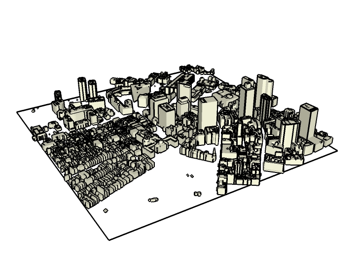
The city model includes a collection of more than 128,000 individual building models, that originate form several sources. This collection is shared as seamless city-wide collections in ESRI Shapefile format (multipatch); tile-specific collections of models in Wavefront Object format; and as a layer in tiled Sketchup models.
Purpose
This building model collection is a record of systematic observations of the 3D form of the city at several points in time. The models may be used as a visual reference that includes the shape and location of buildings. It can be used as a setting for design studies, as a contextual framework for connecting information from sensors or historic documents. These data wil lbe useful for historians who are interested in preserving the record of the shape of the city through time.
Sources
The BOS3D Buildings and Bridges layer is composed of 3D models from a variety of sources. Most of the models originated with a 2011 photogrammetric survey by Infotech. This survey established building polygons with heights. These polygons have been extruded to create level-of detail 1 (LOD 1) buildng models. Specific areas of the city have been augmented with more detailed interpretation of the same 2011 photogrammetry to develop more detailed roof geometry (LOD 2.5). This work was carried out by CyberCity 3D. Bridge models and models of and buildings that have been subject to Article 80 large project review were modeled by the BPDA's Urban Design Technology Group. Many of these models include richer architectural detail (LOD 3). A few models have been contributed by other collaborators as noted inthe Model Source attribute (see below)
Organization
The BPDA's building model collection is issued in a variety of formats for different purposes.
It should be noted that the concept of "Building" expressed in the name of these data is a roofed structure that can be identified from aerial photographs. In the case of buildings that are attached to eachother, a model may use a single model to represent a group of buildings as theyu might be defined by the property tax assessor. In some cases, a building may be represented in these data sets as multiple building part models.
City-Wide Building Model Collection in ESRI Shapefile Format
ESRI Shapefile (.shp): an open data format used by GIS tools, integrates 3D geometric objects (multipatch) with a database table. At each update, a new shape-file iss issued for the current buildings collection and the cumulative collection of retired models for users who are interested in historical applications.
Building Model Collections as Tiled Collections of Wavefront Objects
Wavefront Object format (.obj) is an open data format that is important because of its broad support by free and open source tools for modeling and format translation. On each update release the BPDA exports the entire collection of active models as .obj files, organized in folders according tile. These folders may be downloaded from the BPDA Data Download Map.
Building Models in Tiled SketchUp Models
SketchUp format (.skp) is a proprietary data format that is imported -- but not exported by most commercial 3D modeling tools. .skp format has the advantage of packaging multiple models into a single import/export while maintaining object identity, hierarchy and layer information. Building models are included in SketchUp models that are discussed in more depth on their own metadata page: Tiled Sketchup Models.
Updates
The BPDA issues updates of the building model collection at irregular intervals depending on activity. Each update may include models of several New buildings along with models of neighboring buildings that have been articulated eliminate parts that represent demolished parts. Updates also include Retired models that represent demolished buildings or models that have been retired or superceded.
Each new release of updated tiled models and city-wide shapefiles includes all of the new and articulated models. To facilitate users and applications that use the BPDA buildings in their independent city models or achival tools, updates are issued as separate city-wide collections that reflect just the changes. These releases allow the BPDA's collaborators to apply updates with a minimum amount of disturbance to their independent models.
Updates as City-Wide SketchUp Files
Users of commercial 3D modeling tools may find it easiest to apply updates by importing the city-wide updates as SketchUp format models. The advantage of this format is that all updates can be imported in a single step. Some clean-up may be neccessary to delet or hide the models of buildings that have been demolished.
Updates as City-Wide Collections of WaveFront Object Files
For applications involving open-source tools, updates are issued as city-wide collections of Wavefront Object files. These collections include both new and retired models associated with the update cycle. A CSV file is also included, which provides atteribute information for each model.
Building Model Attribute Tables
Building models come into the BPDA's city model management system from many sources. Building models may go through several status-phases in their life-cycle from proposal to demolition. The GIS-based model management system uses a unique Model ID that links each model to attributes that reflect information concerning sources and status. The the BPDA's Model ID scheme is designed to be extendable by independent collaborators as descrived in more detail inthe Boston 3D City Model User Guide
In the GIS-Based management system models and their attributes are linked together by the nature of GIS database. When exporting to data formats used by design and archival systems, it is necessary to provide the model attributes as a separate table. This attributes table can be used to automate operations including bulk import and registration, or to record model information that is created outside of GIS applications.
The Building Model Attribute Table as Comma Separated Values
A comma-separated values table (.csv) is a plain text file that represents a table. These canbe very easily viewed in spreadsheet tools or used in scripted workflows. A city-wide buildng model attributes CSV can be downloaded from the Boston 3D Data Download Page. A tile-specific CSV table is also included with each folder of tiled obj files.
Building Model Attribute Dictionary
| Field Name | Type | Description |
|---|---|---|
Name |
Text |
Name of the building or Article-80 project. |
Model_ID |
Text |
A unique identifier for each model. Tghis provides the link with the file-names of models exported as Wavefrot Object (.obj) files or the group names of building models exported as SketchUp format documents. |
Build_ID |
Text |
Building ID. Currently set according to the Parcel ID intersected by the centroid of the building part. Note that the relationship between building models and parcels is not strictly one-to-one. |
Status |
Text (Domain) |
Establishes the stage of the lifecycle for the building. Values of Status are taken from the Status_Code domain (described in more detail below). |
Appear_Dt |
Date |
This is a date field that designates when the building would be turned on if a time-slider were used. It is not necessarily the date that the building part was built. It may be just the first known appearance of the building part. |
Appear_Src |
Text |
This text elaborates on how the Appear date was established. |
Editor |
Text |
The name or the person that edited the feature. |
Model_Src |
Text |
The source of the model. |
Lineage |
Text |
A description of the lineage of the model. Reflecting the original survey or source and the transformative steps that have created the model. |
Model_Dt |
Date |
The date of the model. |
ObliqueLnk |
Text |
A hyperlink that brings up an oblique view of the building in Google Streetmap. |
Centr_Lat |
Double |
Latitude of the centroid of the building i decimal degrees. |
Centr_Lon |
Double |
Longitude of the centroid of the building i decimal degrees. |
Tile |
Text |
Identifies the tile in the Boston 3D tiling scheme that enclosed the geometric centroid of the building model. |
Parcel_Use |
Text |
Land use of the parcel that the building part centroid falls inside. |
Coordinate System
See the Bos3D User Guide for more discussion of the BOS_Shift Coordinate System.
Projected Coordinate System: State Plane Massachusetts Mainland FIPS 2001 Feet, NAD1983
Coordinate offsets: 732,200 feet West and 2,902,900 feet South.
Vertical Coordinate System: NAVD 88 Feet (Height)
Usage Notes
- When importing Wavefront Object files from the BPDA into your modeling tool, specify that the Z Axis: Up and the Y Axis: Forward. Otherwise your terrain model will beoriented incorrectly.
- For tips on formatting your own models for sharing with the BPDA, see the Sharing Models section of the Boston 3D Model User Guide.