What's New? The BPDA GIS Department has made many changes to make it easier for neighbors and makers of all kinds to collaborate on the application, improvement and extension of the city model. Click here to read more about it!
Data Download
The Boston Planning and Development Agency (BPDA) maintains a 3D model of the city as a visualization and analytical tool for understanding ideas related to the future of neighborhoods. The BPDA shares the Boston 3D city model in several formats intended to facilitate collaboration between diverse communities who have an interest in understanding places in the city as they have changed or as they may be changed. Find an overview of the BPDA's city model sharing strategy in Boston 3D User Guide.
Tiled City Model Components
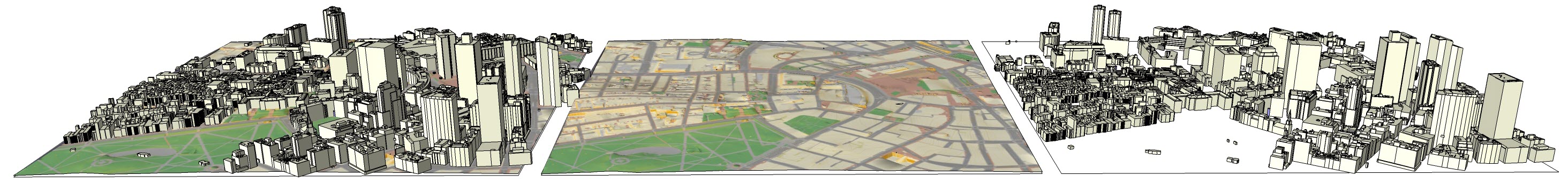
The BPDA maintains its city model using a scalable geographic information system to bring together city model components: terrain models, with draped ground-plan, recent aerial photography and 3D building models. To make it easier for users of 3D modeling tools to aquire complete 3D model covering specific area of interest, the BPDA provides each model component clipped to a system of 5,000 foot square tile modules that snap together. We publish each of the components using open-source data formats, and also as an integrated SketchUp model that combines all of the pieces for each tile.
Click the blue info-dots  , below,
for more information and tips for using each of the of the tiled model components.
, below,
for more information and tips for using each of the of the tiled model components.
See the links at the bottom of this for information about seamless city-wide layers, incremental model updates, tile-grids and other resources. Specifics regarding the coordinate system and tips for using the BPDA model as a setting for developing sharable building and site models can be found The Boston 3D Model User Guide.
| ||
| Sketchup Model |
Terrain with groundplan in OBJ format |
Buildings in .OBJ format |

| ||
| Base Maps: PNG , PDF |
2020 Aerial JPEG |
DXF Base Map |
Click the Map to Download Tiled Model Resources
This is a draft page: the data links in the map below are not working at the moment
For Seamless city-wide data-sets jump to the bottom of the page.
More Boston City-Modeling Resources
After two years experience sharing and collecting 3d model resources from a variety of users, the BPDA has re-engineered the framework for maintaining versions of the models at different sites, and for interchanging models between various applications. Quick-links are provided below for seamless city-wide resources for modeling and automation.
The Boston 3D Model User Guide
Quick-Links from the The Boston 3D Model User Guide:
- Interoperability strategy.
- Exchange Formats for 3D Model Components
- Persistent Model Identifiers and Attributes
- Coordinate System Details
- Updates and Version Control
- Sharing models with the BPDA or other users
City-Wide Seamless Data-Sets
This is a draft page: the links below are not workng at the moment
-
Latest City-Wide 3D Buildings Feature Class: Esri shapefile (Multipatch)
- The Tile Grid in shapefile, DXF, SketchUp and CSV format
 Download thelatest updates as citywide Sketchup or Wavefromt Object format files.
- City-Mode components published by the BPDA Urban Design Technology Group. Includes 2D CAD and 3D model files organized by Boston neighborhoods.
- Additional 2D GIS Data is available through the City of Boston's GIS Data Hub.
Disclaimer
Disclaimer: The Boston Planning and Development Agency (BPDA) recognizes the value and benefit gained by sharing Geospatial data. Although the BPDA has made reasonable efforts to provide accurate data, the Agency makes no representations or guarantees about the accuracy, completeness, or currency of the information provided. The BPDA provides this data as is and with all faults, and makes no warranty of any kind. Each user is responsible for determining the suitability of the data for their intended use or purpose. Neither the City, the BPDA nor its affiliates, employees, or agents shall be liable for any loss or injury caused in whole or in part by use of any data obtained from this website. The geospatial data is updated and modified on a regular basis and users are encouraged to report any errors to the BPDA.